Real-Time Location Systems for Safety and Efficiency
Celebrating two decades of technological excellence, Litum stands at the forefront of location innovation. Find out how we make workplaces safer and operations smoother through RTLS.
20 Years of Innovation
At Litum, we’re transforming the future of workplace safety and efficiency with proven real-time location systems (RTLS). With two decades of innovation, our systems offer unparalleled precision in real-time location tracking, significantly improving safety and operational visibility across various sectors. From enhancing personnel safety to optimizing asset utilization, our systems deliver tangible results. Our user-friendly and robust technology fits seamlessly into multiple industries, offering not just a product, but a partnership in driving your business towards a safer, smarter future.
Benefits of Litum RTLS Solutions
- Highest precision with Ultra-Wideband RTLS technology
- Improved accuracy with TWR & TDoA location detection methods
- Wide coverage (large spaces, multi-floor, multi-site with unlimited number of objects)
- Minimal infrastructure requirement
- A fully integrated indoor location tracking suite with full line of sensors and software
- Flexible integration with 3rd party systems
- Customizable reports and screens to support varying business requirements
- Employee privacy protection mechanisms
Real-Time Location Systems (RTLS)
RTLS is a real-time indoor location tracking system that locates and monitors any person or asset within a defined zone covered by an RF network. RTLS solutions utilize a combination of hardware and software to create an indoor location tracking network. This network uses receivers (also known as RTLS anchors) placed throughout the area to receive the signals sent by active RTLS tags.
RTLS tags are made up of a small antenna, motion sensors, RTLS microprocessor and a battery. Most batteries on RTLS tags can last for months before needing to be recharged. The tags transmit a few times in a second or once every few seconds or minutes, depending on how often you want to refresh the location data (refresh rate.)
The signals captured by the RTLS anchors and directed to RTLS gateways connected to the local network. All data within the signal is sent back to a location engine software, where the exact location of each tag is calculated and positioned on the facility map.
UWB
UWB is a RF communication technology for short-range use for the fast and stable transmission of data, both indoors and outdoors. It is based on the combination of very short pulses moving at the speed of light.
UWB RTLS solutions don’t interfere with other technologies as its bandwidth (3.25 — 4.75 GHz & 6.25 — 6.75 GHz) differs from WLAN and ISM radio bands reserved for industrial and medical use.
UWB radio not only can carry a considerable amount of data over a distance up to 230 feet (70 m) at low power (less than 0.5 milliwatts) but can carry signals through doors and other obstacles that tend to reflect signals.
UWB RTLS technology can be used for a variety of applications such as asset tracking, employee tracking, forklift tracking, and more. We use this in our indoor location tracking technology for accuracy and reliability.
Geofencing
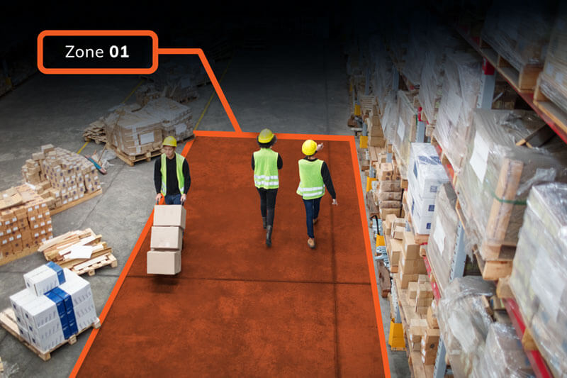
Geofencing is a virtual zoning service where RTLS Software (Business Rule Engine) triggers an action or a set of actions when an RTLS tag moves into or outside of a monitored zone, referred to as a geofence.
Geofenced zones can be defined based on the needs of each business and can be set as free, restricted, monitored, or hazardous zones with Litum RTLS software. A geofence could be a department, a work area, a floor, or a cluster. Each zone is marked on the actual facility map for a visual demonstration.
Our RTLS indoor location tracking solution allows a variety of business rules defined for each zone; number of people allowed, etc. Also, the zones can be defined as value-added work areas, or non-value-added work areas that can be used to analyze the time spent on the workforce performance.
Detection Methods of UWB RTLS Technology
There are many indoor location detection algorithms available for indoor positioning. Each determination method has its own pros and cons. Below are the most commonly used ones:
Two-Way Ranging
(TWR)
TWR offers maximum precision and positional stability. The anchor sends a UWB signal and the sensor returns it. The distance between the anchor and the sensor is determined by the time required for the UWB pulses. A position can be determined as soon as the distance of a sensor relative to different anchors is available. The TWR method is mainly used for the localization of workers, tools, and navigation of driverless transport systems.
Time-Difference of Arrival
(TDoA)
In the TDoA position determination the sensor transmits a signal which is received by the anchors at different intervals relative to the distance of the sensor. The position of the sensor is determined by the interval differences. Positioning with TDoA is mainly used for the localization of a large number of objects. It has the lowest energy consumption among the available methods on the market.
Angle-of-Arrival
(AoA)
The AoA method evaluates the phase difference between the received signals at the two antennas of an anchor. Based on this, the angle of the signal relative to the anchor is calculated and thus the position of the sensor can be determined. AoA indoor location tracking technology is generally used for position determination when there is a limited infrastructure and additional information is to be used by the sensor signals.
A business rule engine (BRE) is a component of software allowing non-programmers to change the business logic in a business process management (BPM) system. To carry out a business policy or procedure, a business rule or statement is required. Business logic uses data in a database and a sequence of operations to carry out the business rule.
Litum BRE allows businesses to create as many rules as they require to effectively manage safety and efficiency in their operations. Business rules could be as simple as “social distancing” or as complex as “crane work zone safety”.
A location engine is a server that interprets all the data the RTLS system is collecting through its mesh network. At the end of this process spaghetti diagrams, heatmaps and many other types of visual reporting can be produced.
Explore Our Resources

Find out more in our blogs and insights
See all posts

